At the western extreme of the Australian continent, Shark Bay is a vast network of embayments, islands and peninsulas, with unique marine habitats including hypersaline waters. Shark Bay supports the largest (4,800 sq. km), most diverse underwater sea-grass meadows in the world, has a resident dugong population of approximately 16,000 animals, and the hypersaline reaches of the Bay provide the best conditions on Earth for stromatolites – colonies of algae forming hard dome-shaped deposits – among the oldest forms of life on earth.
Shark Bay is also home to five species of endangered mammals, and is famed for the dolphins of Monkey Mia that interact with human visitors on the beaches each day.
Shark Bay World Heritage Interpretive Centre
The centre is a new building in the town of Denham on the Peron Peninsula, Shark Bay, designed by architect John Nichols. Exhibition design is by Freeman Ryan Design, Australia’s leading museum and gallery design agency.
I provided all multimedia services for the permanent exhibition including technical systems design, media acquisition and production, installation and commissioning.
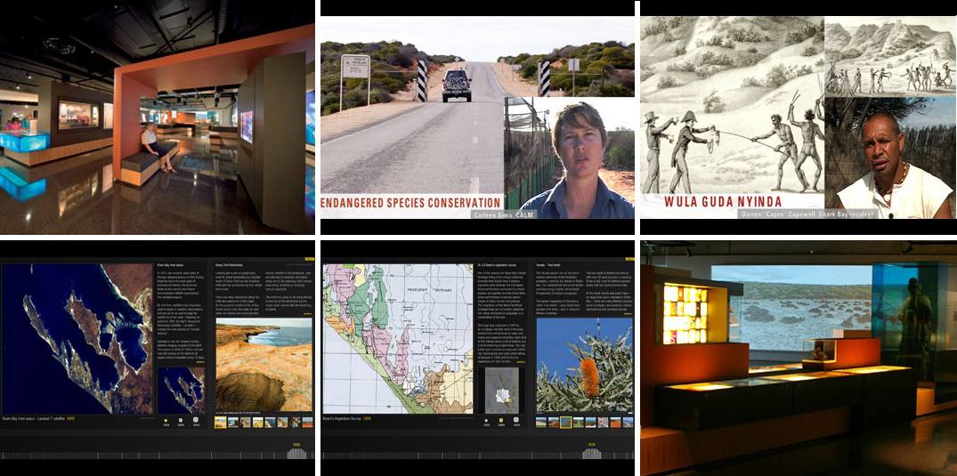
The centre presents a comprehensive series of displays exploring social histories, environmental significance, scientific importance and natural beauty of the World Heritage area. It opened to the public in December 2005. There are four multimedia elements in the exhibition.
World Heritage Values
The first space visitors enter is a large cubic volume. Here, the exhibit reflects upon the reasons Shark Bay is a World Heritage listed area, one of only a few in the world to satisfy all four key values.
Three walls feature large lightbox displays. Three iMac computers display hundreds of digital photos and hours of footage I shot and sequenced, showing the terrestrial and aquatic envinronments and diverse landscapes of the region. A large tactile map of the region is etched into the concrete floor to help visitors understand the lay of the land.
A 12 speaker soundscape fills the room with environmental audio derived from a series of field trips to remote parts of Shark Bay. Over 90 minutes, the soundscape moves through various habitats, times of day and night, and weather conditions, creating a virtual tour of the region. Sequences include the rare event of frogs calling at midnight after winter rains, waves crashing on the Zuytdorp cliffs, underwater recordings of dolphins and marine life, the roar of coastal blowholes, and more. The soundscape was commissioned by CDP Media and produced by David Chesworth of Wax Sound Media.
Mapping Interactive
An interim zone connecting the opening space and main exhibition hall features a pair of high-resolution Macintosh-based interactives exploring mapping of the Shark Bay area from 1616 to 2005. It reveals the earliest European depictions of fragments of the coastline, maps of 18th century French explorers, 19th century pearling leases, 20th century mineral exploration and pastoral leases, and 21st century photographs of Shark Bay taken from the NASA space shuttle.
Visitors can select maps from a timeline, interactively zoom and examine them in fine detail, read interpretive texts and view associated photos and movies.
I commissioned my colleague Robert St Clair to develop the custom software engine, built in Macromedia Director’s lingo programming language. I created all media elements for the interactive including interaction design, digital imagery, quicktime movies, subject research and text files.
The interactive presents 14 high-resolution, zoom-able key maps with over 5,000 words of text, 120+ support images and 70 minutes of Quicktime.
Talking Points
An important aspect of the interpretive experience is the voice of people who have lived and worked in Shark Bay. The ‘Talking Points’ project presents 29 illustrated video interviews with local people, scientists, museum workers and staff of the WA Department of Conservation and Land Management.
The interviews present a variety of perspectives on Shark Bay, representing the diverse human involvement with the environment from industries such as pearling, fishing, pastoral and mining, to experiments in captive breeding of endangered marsupials, marine sciences, maritime history, botany and Aboriginal heritage.
There are two Talking Points ‘stations’ in the main exhibition space, each with a different program of interviews, designed to allow visitors to sit on built-in benches, or stand, to watch and listen to as many or as few stories as they might be interested in. In total, there is almost three hours of media in the Talking Points programs, ensuring that visitors will have a different experience each time they visit the Centre.
I recorded and edited all video interviews, took over 3,000 digital photos, made audio field recordings and secured rights to all third party media for the Talking Points project. The movies were created using Final Cut Pro and are delivered in the exhibition space as Quicktime movies direct from hard disc to plasma screens.
Environment Screen
The end wall of the main exhibition space features a large-scale data projection – 6m wide x 2.4m high. This screen shows a 90 minute looping sequence of slow-moving imagery depicting the many diverse environments of the Shark Bay World Heritage area. Visitors may not get to visit some of these places due to their remoteness – the WHA is over 250,000 square kms and many locations require long hours of 4-wheel drive travel through harsh, variable conditions – so the Environment Screen is designed to reveal the richness and diversity within the region.
The custom-ratio Quicktime movie uses high-resolution digital photography and windowed video sequences composited in Adobe After Effects. It plays back from a Macintosh mac-mini computer sending a DVI signal to a twin-lamp Panasonic DLP data projector.
I commissioned panorama photographer Peter Murphy to accompany us on a field trip around the region, making 360º panorama sequences at key locations. The resulting digital files were used to create Quicktime-VR panoramas for the Mapping Interactive and slowly panning movie sequences for the Environment Screen.
gary warner 2012
___
Services
concept development
design development
digital media recording
multimedia production
sub-contracting
technical systems design
technical specification
installation
commissioning
Contract Period
May 2003 – Dec 2005